
The park headquarters also keeps a passport stamp. After I explain this year’s journey to over 320 parks year to date and share the pin project, the rangers at the desk suggest I should meet Ranger Ted, librarian for the Grand Canyon National Park Research Library. They direct me across a courtyard to the building’s far corner and Ted’s office. Ted and I engage in a diverse conversation about the parks and park service. I explain, “I’ve enjoyed this year so much. The whole year has been a once-in-a-lifetime experience. But I’m starting to get tired, a deep kind of fatigue that doesn’t go away after a single night’s rest or even a few days off. And I’ve been fighting a chest cold the past week. I’m afraid I’m wearing thin.”
Ted responds, “You’re near the end. You must finish now if you’re going to write about it. And you should finish. It’ll be a great story. I would love to read it when you’re done.”
“Thanks for the kind offer,” I reply before turning to leave. Almost as an afterthought, I pivot and say, “You know, everywhere I go in the park system, your colleagues validate the reasons behind the pin project. I’m deeply touched by the kindness and encouragement. As I’ve started to falter down the home stretch, some ranger or volunteer will give me a mental boost when I need it most. Even my wife, who thought I was crazy the first six months, is telling me I have to finish.”
A warm smile spreads across Ted’s face, and he replies, “You get what you give. Now go finish and be safe!”
My final stops are Yavapai Point Visitor Center and Geology Museum and the Grand Canyon Visitor Center near Mather Point. During our first visit here, I told the rangers I had visited a park recently that had its passport stamper stolen and pondered why anyone would want to steal such a thing. “What would you do with it?” I asked. The rangers told me they had a visitor at the ranger desk who turned around in full view and tried to shove a stamper into his pants. Shocked, the rangers managed to ask, “Sir, what are you doing?” before he got it past his belt. Since that time, I’ve learned that visitors steal stampers across the system. Many go missing during visits by groups of children. One park told me that they’ve lost three stampers to visiting Boy Scout Troops. Hearing these stories disappoints me.
After finishing my stops on the South Rim, I start toward Page, Arizona, where I’m staying three nights to see the last two unexplored parks in Utah’s Colorado River Plateau. I will also enter the south end of Glen Canyon National Recreation Area after traveling through the north end in March. Today, I have three late-afternoon destinations. From the Glen Canyon headquarters, I drive to the park’s Carl Hayden Visitor Center. From there, today’s last stop is a personal favorite.
Five miles south of Page, the Colorado River makes three sharp turns at a place known as Horseshoe Bend, part of Glen Canyon National Recreation Area. The horseshoe is carved with a straight drop over one thousand feet from the rim to the river below. Kareen and I stopped here in 2014. A wind storm blew across the desert, with sustained winds over 35 mph and gusts over 70 that tore my hat off. Despite the wind, I was determined to see this place. Horseshoe Bend’s grandeur in person surpassed the attraction’s popular aerial photographs. I wanted to take a picture of the whole “shoe” from the rim. With no guardrails or man-made barriers, the only way to get the picture is by extending the camera over the edge. I pulled my hat from under my wind jacket where I had tucked it away, handed it to Kareen for safekeeping, laid flat on the ground, and crawled to the precipice. As gale force winds tore over us, blowing dust in my eyes and flapping the back of my jacket, I reached the great abyss, shuddering at the thousand feet of open space straight down to the winding river below. Carefully reaching out with my camera, the strap wrapped around my neck, I hear Kareen yelling something into the wind. Unable to understand her and stunned by her sense of timing, I yell back, “Good grief! Whaaat?”
She yells louder, “Do you have life insurance!” We hadn’t reached our first anniversary at this point and already she’s weighing her options.
Today under calm skies, I stand over the abyss enthralled by Horseshoe Bend. My peaceful solitude is free of hurricane-strength winds and a wife hoping to off me for cash. It’s lovely.
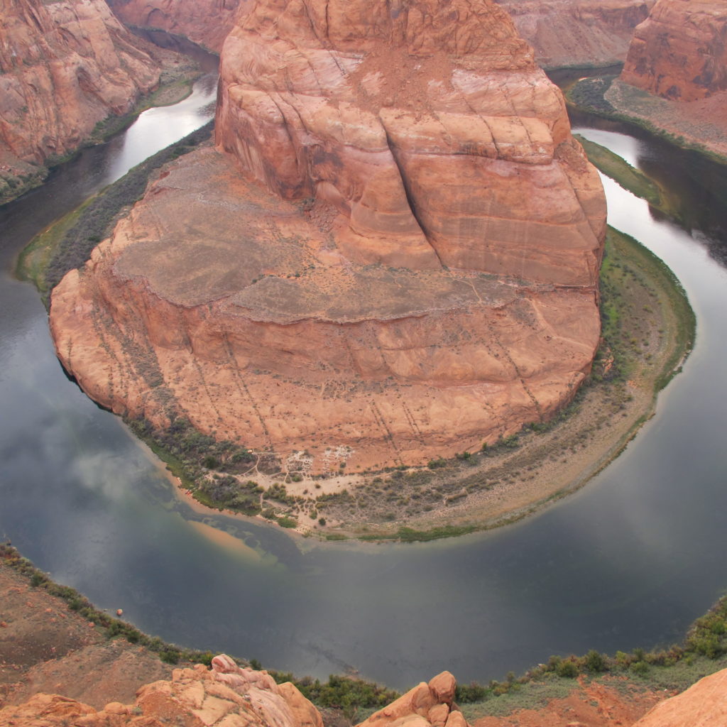
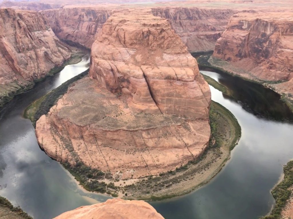
Horseshoe Bend
Wednesday, I’m taking the park boat tour from Wahweap Marina near Page to Rainbow Bridge National Monument, a separate unit located within Glen Canyon National Recreation Area. The fifty-mile Lake Powell boat trip passes Glen Canyon’s towering cliffs and carved rock. The two-hour passage climaxes at the world’s largest natural bridge, spanning 275 feet across and rising 290 feet from base to top. The massive arch’s center measures 33 feet wide and 42 feet thick. Melt and flood waters from 10,388-foot Navajo Mountain, six miles away, cut through a protruding fin of Navajo sandstone to produce the shape we see today.
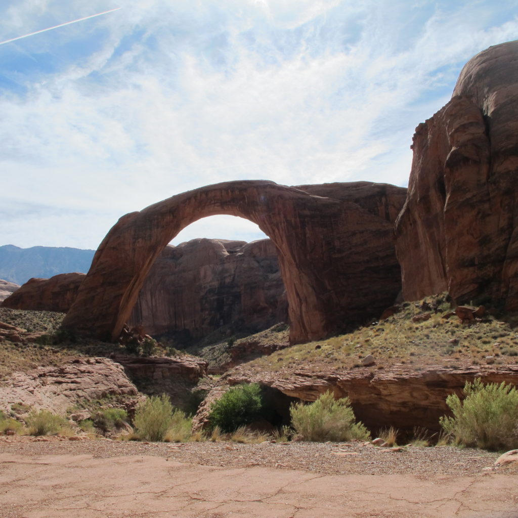
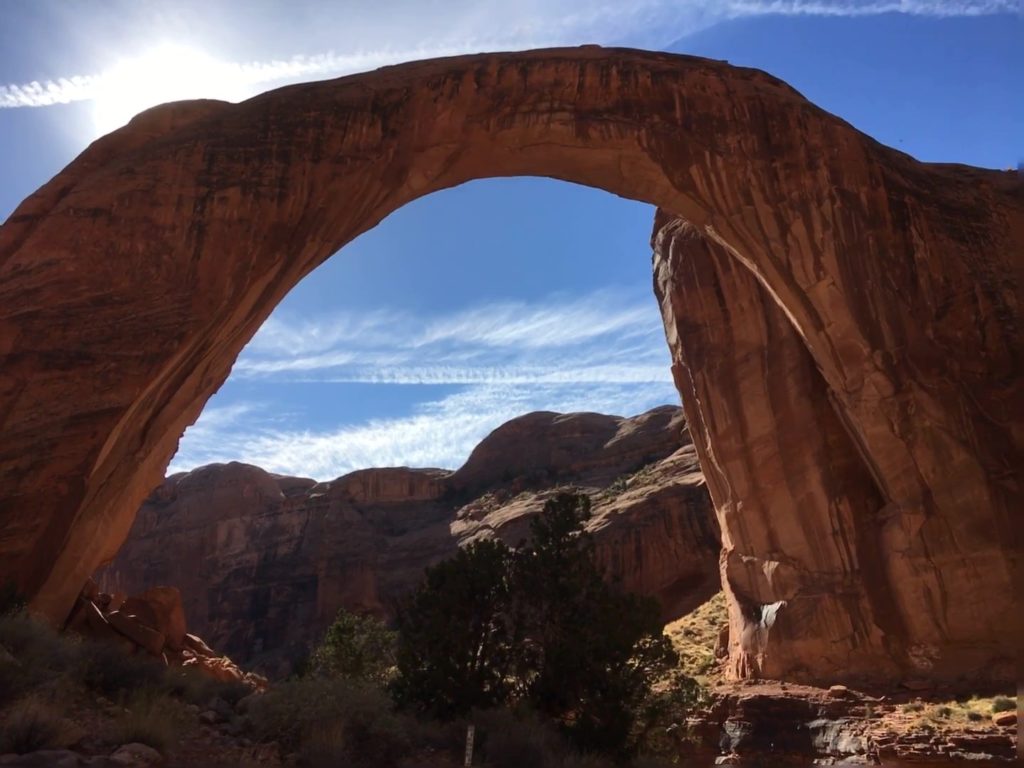
Rainbow Bridge
Considered sacred by Native American tribes, the park service asks visitors to avoid walking under the bridge, a sign of disrespect. Most visitors observe the bridge from a viewing area about two hundred feet away. A trail from the boat dock leads into Rainbow Canyon and the bridge. At higher water levels, boats could travel to within a few hundred feet. The current drought and low water level leave almost a mile hike. I walk ahead of the group and reach a ranger under a small shelter. She has a traveling case with interpretive aids, junior ranger booklets, and other supplies.
After most of the group is nearby, she points out a fossilized dinosaur footprint in the sandstone. Native Americans guided the first white people to see the bridge in 1909. Early outside explorers needed weeks to make the journey. Those early visitors included Theodore Roosevelt in 1913.
The next day I head north and west to the Bureau of Land Management (BLM) Grand-Staircase Escalante National Monument Visitor Centers in Big Water, Utah, and Kanab, Utah. Continuing north on US Highway 89 and then left on Utah Highway 14 brings me to Cedar Breaks National Monument, a massive rock amphitheater at 10,500 feet. The eroded west face of southwestern Utah’s Markagunt Plateau features an amphitheater over 2,000 feet deep and over three miles in diameter. The monument’s eroded red sandstone looks like a smaller, flipped version of Bryce Canyon, facing west instead of east. The visitor center is already closed for the season, so I travel the rim south to north stopping at overlooks.
From Cedar Breaks, I drive to lower elevations through the Dixie National Forest. Brilliant yellows decorate the clustered trees for miles. I pass Bryce Canyon on my way to the Grand-Staircase Escalante National Monument visitor center in Cannonville, Utah. Scenic Highway 12 works its way up ridges and around plateaus through the eroded landscape of the grand staircase stepping down through the Colorado River Plateau from the north to the Arizona border.